Taiwan-Made TRITON Satellite Fully Assembled, Expected to Be Ready for Use by End of 2022

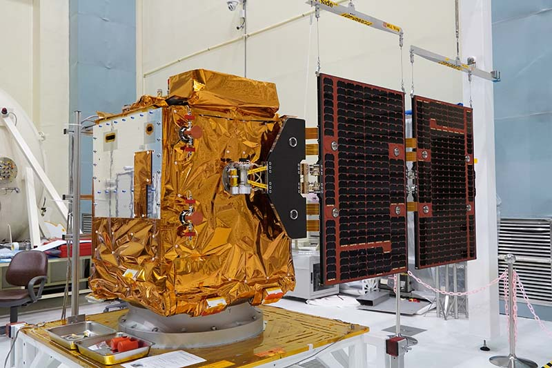
The TRITON (FORMOSAT-7R) satellite, independently developed by NARLabs' National Space Organization (NSPO), an institution under the Ministry of Science and Technology (MOST), has recently reached a new milestone. With the installation of its solar panels, assembly of the satellite is now complete. After a series of environmental and functional follow-up tests, the satellite is expected to be ready for use by the end of the year. It is planned for launch at the Guiana Space Centre in French Guiana on a VEGA C rocket from French company Arianespace in the first quarter of 2023 at the earliest.
TRITON, a wind observation satellite, was originally part of the FORMOSAT-7 project as an independent satellite named FORMOSAT-7R, but was later renamed TRITON after adjustments were made to the mission. Unlike FORMOSAT-7, which directly receives GPS and GLONASS (Global Navigation Satellite System) signals refracted by the ionosphere and atmosphere, TRITON is equipped with Taiwan-made Global Navigation Satellite System-Reflectometry (GNSS-R), which collects global navigation satellite signals reflected from the surface of the sea in low Earth orbit and uses the physical characteristics of the reflected signals to extrapolate the speed of the wind at the sea surface.
TRITON is the second satellite after the FORMOSAT-5 to be developed in Taiwan. The entire satellite, including its payload, is 82% developed and manufactured in Taiwan, and if ground equipment is taken into account, over 20 Taiwanese R&D teams and manufacturers were involved. After the launch, TRITON will also test and validate 10 key components and technologies designed and manufactured in Taiwan.
The satellite's Chinese name, meaning "Wind Hunter," was chosen by public vote, and its English name, TRITON, was derived from Greek mythology. Triton is the son of Poseidon, the god of the sea. In addition to inheriting the trident, a symbol of the god of the sea, he also possesses a conch. Whenever Triton goes on patrol, he blows the conch to raise the wind and waves, over which he has control.
Wu Tsung-Tsong, Minister of Science and Technology, stated that TRITON benefitted from NSPO's experience with the FORMOSAT-5 and further increased the proportion of Taiwan-produced space technology. These technologies include key components such as the satellite computer, power control, fiber optic gyroscope, and navigation receiver, as well as important payload instruments. NSPO has also developed a number of key technologies itself, clearly showing that Taiwan has the power to build satellites. Coupled with Taiwan's already advanced ground equipment technology, the country will not be missing out on the global boom in low Earth orbit satellites.
Wu Jong-Shinn, Director General of NSPO, explained that Taiwan's locally developed GNSS-R apparatus uses unique technology for firmware optimization and can receive up to eight datasets simultaneously. It can also receive reflected signals from Japan's QZSS (Quasi-Zenith Satellite System) in East Asia, with better performance than instruments from abroad. Data processing and application technologies were all developed by NSPO in cooperation with National Central University, National Cheng Kung University, and the Central Weather Bureau, and will enhance how the collected data is applied.
According to TRITON program leader Lin Chen-Tsung, now that TRITON has received its solar panels, the completed satellite will undergo mass properties measurement, vibration testing, sonic vibration testing, and separation pyro shock testing, as well as a final comprehensive test. When testing is completed and the satellite passes a review meeting before transport, it will then be considered ready for launch and await shipment to French Guiana.
When in orbit at 550-650 km, TRITON will receive GPS and GLONASS signals sent out and reflected off the surface of the sea. Wind field data calculated from these signals is currently the most lacking type of meteorological data, and along with high-resolution coastal wind field data from ground-based radar, it can help predict typhoon tracks, heavy rainfall, and air pollution, as well as be used in research on sea-air interaction, among other topics. It can be said that TRITON plays two roles; it is both a weather satellite and a scientific satellite.
.jpg)
.jpg)